Assignments Based on NR 533 Topics
NR 533 - Application Issues in Geographic Information Systems
Project - Wack County Property Parcels Query
Project Requirements
Incorporation elements
- Modelbuilder
- Python Script
- Data Model - Geodatabase
- Web Application
- Short Description of the Project (less than 3 pages)
Overall Expectation
- Transportable
- Complex Geoprocessing
- Self Documenting - can understand without consulting the author
- Part of Portfolio
Project Goals
The goal of the project was to create a parcel lookup system for Wake County property parcels. Users are able to submit a complex set of search criteria via a SQL statement and receive a list or selection set of parcels matching the user-specified search criteria.
Initial Data Sets
All data was obtain from the Wake County GIS website.
- Wake County Parcels (shapefile)
- Major Wake County Roads (shapefile)
- Wake County Floodplains (shapefile)
Personal Geodatabase Construction
The Wake County Parcels layer was used as the basis to create a feature class inside a personal geodatabase. Look up tables to explain and provide descriptors for the various codes used in the parcel table. Linked tables were deliberately not used in this case. The parcel data is considered static since Wake County does not publicly provide real-time updates of parcel data online.
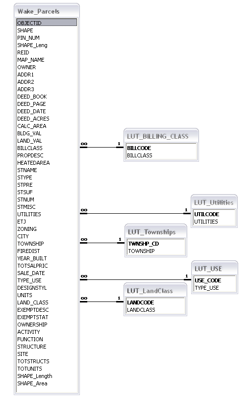
Project Personal Geodatabase ER Diagram
Model Builder
Model Builder was used to create a complex query tool. A Select by Attribute object was used to perform and SQL query on the parcels to select all parcel matching the user supplied criteria. Two Select by Location objects were used to removed parcels either inside or outside a user specified buffer radius based on user selected criteria and to remove parcels inside a floodplain area. Once the model is run, the relevant parcel are select from where the used can output a table, report, or shapefile depending on their needs. Due to the complexity and scale of the feature geometry and the large number of parcel polygons (> 300,000), the model can take upwards of 10 min. to run; even on a dual-core or dual processor workstation.
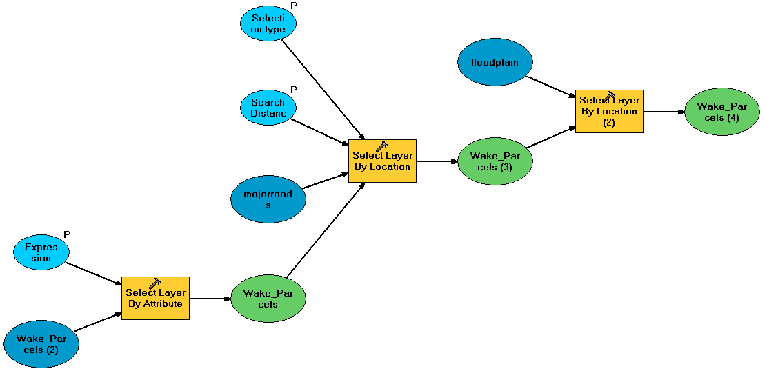
Project Model Builder Diagram
Click image to view full sized
Python
In an effort to allow for a slightly more basic parcel query to be performed without the system resource overhead of starting and running ArcGIS, I wrote a python program to query the personal geodatabase and create a text file with the relevant parcel information. The SearchCursor data access object was used to make a query of the parcel feature class in the personal geodatabase. The function allows to a standard ArcGIS SQL statement to be used. The SQL statement can either be hard-coded in the script or supplied as an input variable. The script produces a tab-delimited text file with the relevant parcel information that can easily be imported into a spreadsheet program such as Microsoft Excel.
query_report.py (click to view code)
Data Trends
The figure below shows the Wake County parcels layer with a symbology denoting the value of land as a function of area. The warmer colors denote land that has a lower cost per unit area value and cooler colors denote land that has a higher cost per unit area value. Two general trends can be noted. First, the most expensive property per unit area is in the center of the city. Second, the northwestern area is more expensive than the southeastern area.

Wake County parcel land value per unit area. Warmer colors denote land that has a lower cost per unit area value and cooler colors denote land that has a higher cost per unit area.
Click image to view full sized
Web Application
The Wake County parcel layer is a very large and very complex data layer with well over 300,000 polygons. To create an online mapping application, the parcel data layer had to be simplified in some way in order to preserve server resources and usability. For the web display, only the parcel data inside the Beltline was used. A simple query tool was added to query for parcels with a certain acreage. The site was visually customized with some additional links added including a link to a page describing the map application. Figure 4 is a screenshot of the web page.
http://congaree.cnr.ncsu.edu/mamille4_map
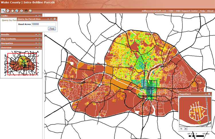
Screenshot of the Wake County parcel web application.
Click image to the web application page.