NR 535 Assignments
NR 535 - Computer Cartography
Project 3 - Map Design for the Internet
In recent years, the use of the World Wide Web as a medium for cartographic communication has increased dramatically. Web- or Internet-based cartography now brings spatial information to millions of map users on a daily basis. The internet medium has some significant advantages over conventional print cartography: the capability to reach very large audiences almost instantly, to facilitate dynamic exploration of spatial information, even to customize map displays interactively. Of course, there are disadvantages as well. Internet map displays are limited in size and resolution and, potentially, color and typographic choices. Complex messages which might be conveyed synoptically in large format print (poster) format must be organized as sets of individual web 'pages' traversed via links among pages. The challenge of internet-based cartography lies in working within the graphical limitations of this medium and in designing presentations that are coherent and easily navigable.
Specifications
Create a set of maps for presentation via the World Wide Web. As usual, the topic is of your choice. Your web site should consist of three to four web pages: a main or 'index' page (index.htm or index.html) with links to two or three 'content' pages presenting graphical and textual information. There might also be links among content pages or to external sites. Your site should contain at least three major graphical components, including at least two maps. Other graphics might be charts, diagrams, photos, etc.
http://www.millercommamatt.com/nr535
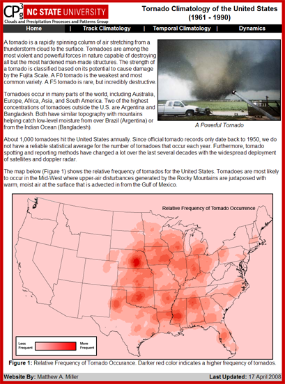
Website Screenshot
The above linked website provides a brief description and climatology of tornadoes. The maps generated for this website where created using ArcGIS and make use of complex symbology and the Line Density function.